Tag Archives: Scenic Drive

Colorado Fall Color – October 5, 2010

LaVeta Pass – US160

Aspen on LaVeta Pass - B

Drove US160 from Fort Garland to Walsenburg crossing LaVeta Pass, elevation 9413’. The aspen were gorgeous, as nice as we’ve seen this year. The yellows were bright and shimmering. While some groves had already dropped their leaves there were still some holdouts awaiting their change. Splashes of orange enhanced the stunning slopes. There was one glorious stand of orange aspen right along the road on the north side near the summit. We didn’t stop for pictures because the thickening clouds were only minutes from precipitation. LaVeta Pass, properly known as North LaVeta Pass, is an easy drive over the Continental Divide in Southern Colorado.

If you’re anywhere near the area in the next week check out the autumn color.

Aspen on LaVeta Pass 2 - B

New Mexico Fall Color – September 23, 2010

Cimarron to Taos

US64

Aspen Promises - West of Angel Fire - B

Aspen Glow - B Green predominates through Cimarron Canyon. Views from Eagle Nest include splashes of colors on Wheeler Peak. As soon as the road turns west from the Angel Fire intersection the promise of fall color increases. Twisting up Palo Flechado Pass many of the aspen are in transition, some green leaves edged with yellow. The peak is yet to come but scattered groves gleam golden or a lone tree absolutely glistens.

Proceeding down Taos Canyon roadside color enhances with yellow-topped chamisa, silvery white dried seed heads, multi-hued grasses and red and orange shrubs against a background of dark green pines.

Roadside Color with Chamisa - B


Further down the canyon willows and cottonwoods add a palette of yellow and gold. A number of artist studios along the route welcome visitors. Combine autumn and art for a engaging tour.

Bright Aspen - West of Angel Fire - B

Colorado Fall Color – September 19, 2010

Striking Gold

Golden Kenosha Pass - B

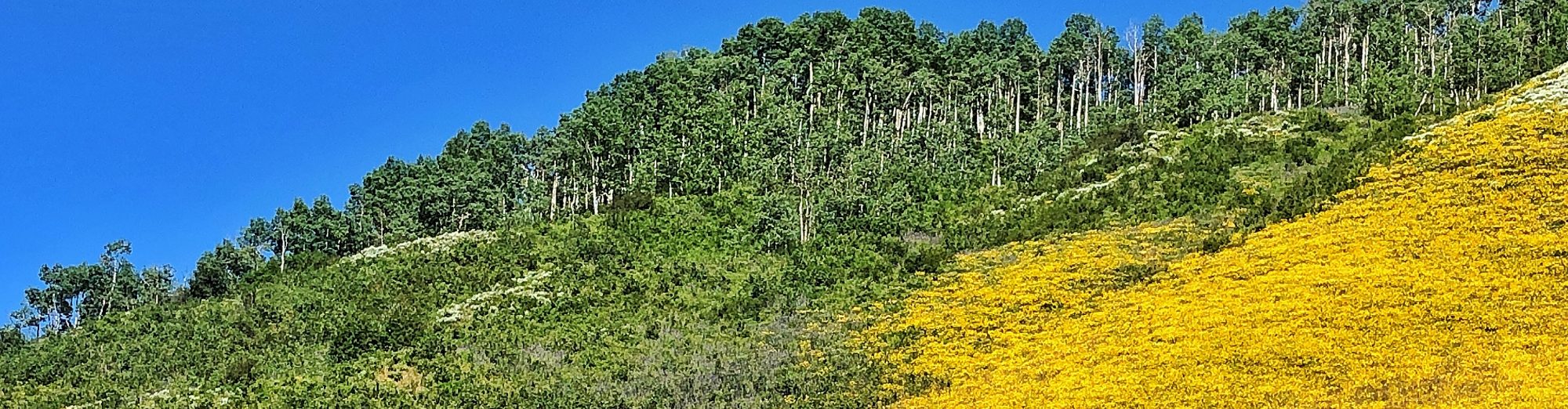
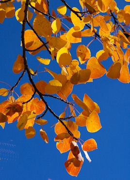
Mountainsides of trembling gold, splashes of orange and red plus cloudless blue skies – a perfect Colorado September day. Hearing forecasts of the fall colors peaking early this year we headed to the hills in search of seasonal glory. We struck gold!Gold Leaves - B

We left Denver on US285 westbound. Just a sprinkling of color appeared until around Grant. Kenosha Pass is heavily forested in aspen and they were truly at their peak – a mother lode of gold. We weren’t the only ones out looking for color; hikers, bikers, horseback riders and photographers jockeyed for preferred positions. The road descends into South Park.

Boreas Pass Road - West Side 2 - B

At Como we turn onto Boreas Pass Road – 21 miles to Breckenridge. Just outside of Como the pavement turns to gravel, a bit rough in spots but car drivable. The route follows the roadbed of the Denver South Park & Pacific Railroad constructed in 1880-81. When completed in 1884 the DSP&P was the shortest route between Denver and the rich Leadville mining district.

3 Daughters Headstone - Como Cemetery - B Looking for photo opportunities we follow a narrow side road and soon find ourselves at the Como Cemetery. Dense aspen stands nearly hide many of the tombstones, some dating back to the 1870s.

The east side of Boreas Pass supports many aspen groves, almost all of which have turned to shades of yellow, gold, orange, red, bronze or rust. Descending down the west side to Breckenridge we find fewer, but bright spectacular groves.

Hoping to avoid Sunday afternoon I-70 traffic we follow CO9 over Hoosier Pass to Fairplay. At 11,542’ elevation the pass is too high to support aspen. However we don’t have to travel far down the south side before mountainsides on the left and right glisten in the afternoon sun.

Backlit Aspen - B After a late lunch at the Brown Burro in Fairplay we head east on US285 over Red Hill and Kenosha Passes back to Denver. Temperatures in the mountains were comfortably in the 70s. Denver set a record at 96 degrees. Even at 5pm the sky was still cloudless; our Rocky Mountain day was truly golden.

Leaves Closeup - B If you want to see aspen at their best in central Colorado make the trip soon before all that glitters drifts to earth.

The route as describe over Kenosha Pass, Boreas Pass, Hoosier Pass, Red Hill Pass and returning over Kenosha Pass is approximately a 200-mile roundtrip from Denver. With lots of stops for photos plus exploring historic sites and cemeteries we made the trip in eight hours.

Orange Aspen Spires - B


Oranage Leaves - B

Colorado Highways and Byways

Open for the 2010 Summer Season

Plows and graders have cut through the late spring snowpack allowing some of Colorado’s most scenic highways to open for the 2010 summer season just in time for the Memorial Day weekend. Openings are always subject to change, dependent on Mother Nature; check on the latest conditions before heading to the hills.

  • Mount Evans Road – CO5 – This seasonal road stretches 14 miles from Echo Lake on CO 103 to 14,130’, just 134’ below the Mount Evans summit. The road claimMount Evanss the title of Highest Paved Road in America. Watch for Big Horn Sheep on the rocky slopes and plan a stop at the Mount Goliath Natural Area. Twisted and ancient bristlecone pines, some more than 1,600 years old) grow in this transition zone between sub-alpine forest and tundra. An access fee applies; exempt for Federal Recreation Passport holders.

  • Trail Ridge Road – US34 – Traversing Rocky Mountain National Park and the Continental Divide, Trail Ridge Road extends 48 miles between Estes Park and Grand Lake. Eleven miles of the highway are above Rocky Mountain National Parktreeline. Forests, lakes, rugged mountain peaks, tundra, wildlife, wildflowers and grand vistas regale park visitors. The popularity of the route often creates slow going – don’t rush, enjoy the view. Icy conditions frequently closes the road overnight early in the season.


  • Independence Pass – CO82 – This narrow, winding road connects Twin Lakes on the eastern side of the Continental Divide  with Aspen on the western slope. Along the 37-mile paved route outdoor enthusiasts find lots of opportunities for hiking, camping, fishing aSlide Scan_Steven and Shawn_8x10[1]nd exploring the ghost town of Independence. Be sure to pack a camera to capture the expansive landscapes, wildlife and summer wildflowers. The faint of heart may want to skip Independence Pass, the road narrows to single lane width in several locations with steep dropoffs and tight curves. Road conditions dictate vehicle weight and height limitations. Hardy souls are rewarded with remarkable mountain scenery and experiences.

  • Cottonwood Pass Cottonwood Pass – FR(Forest Road)209 & FR306 – The 60-mile route between Buena Vista and Almont crosses the divide at 12,126’. The road is paved from Buena Vista to the top of the Cottonwood Pass. The first 11 miles down the west side are graded gravel, auto passable except for extremely low clearance cars. From Taylor Reservoir the road follows the Taylor River, popular with fishermen and rafters. At Almont turn right to Crested Butte or left to Gunnison.

  • Kebler Pass – GCR(Gunnison County Road)12 – This 30-mile Aspen on Kebler Pass segment of the West Elk Loop Scenic Byway connects Crested Butte with CO133. All but 2 miles are graded gravel. Kebler Pass is one of the state’s best drives in autumn when the ample aspen groves glow in golden glory. At CO133 continue complete the 206-mile West Elk Loop back to Crested Butte or turn north to Carbondale and Glenwood Springs.Yellow Aspen Twig[1]


The most dependable aspect of weather in the Colorado mountains is that it can change at a moments notice – or, no notice at all. Always be prepared for changing conditions. Even if it’s 90 degrees in Denver don’t leave home without jackets and closed-toed shoes. Properly prepared you can enjoy your mountain journey no matter how conditions may vary – crystal clear skies to ice crystals.


Saguaro National Park – West: Tucson Mountain District – Tucson, Arizona

Protecting Sonoran Desert Landscape

snp-saguaroWe visited the West section of Saguaro National Park this afternoon. Viewing the cactus studded Tucson Mountains we truly appreciate that the National Park was designated 76 years ago. Today the two segments of the national park bracket the growing Tucson metropolitan area.

More about the park later, meanwhile enjoy a few photos.

snp-flag snp-ocotillo

snp-junior-rangers

snp-vista