Monthly Archives: September 2009

Colorado Fall Color – Gothic

Crested Butte to Gothic


A short but always rewarding side  trip to a Crested Butte visit. “The Butte” isn’t exactCurving Gothic Road Thru Aspen
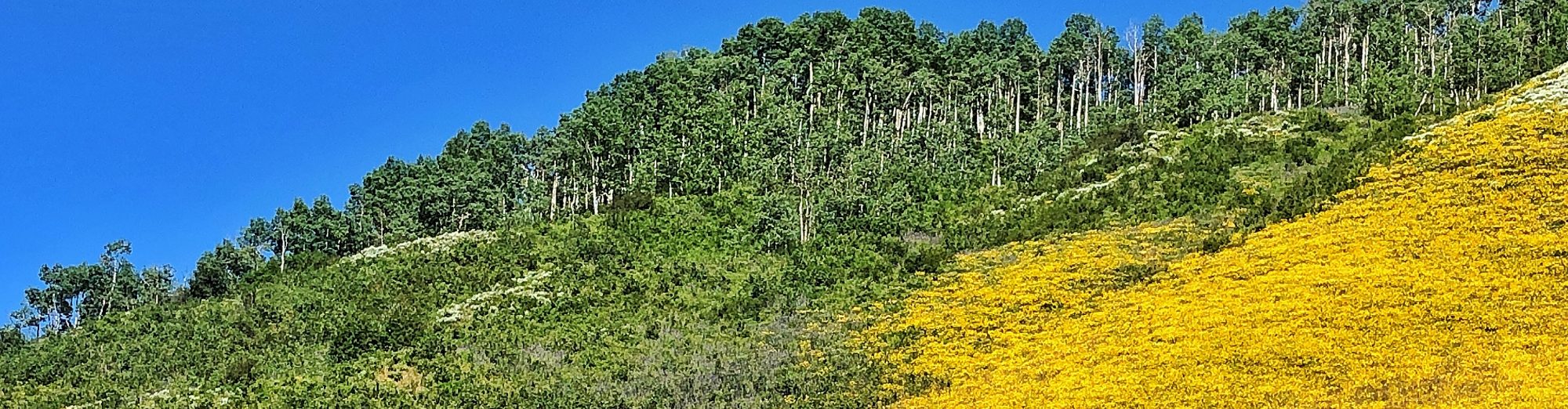
ly a place you stumble upon, you get there on purpose. And, some choose to never leave. A former ghost town, Gothic is now headquarters of the Rocky Biological Laboratory, a high altitude environmental research field station. In several locations on the road to Gothic aspen line both sides of the road forming an overhead canopy. Slopes across the valley support hearty stands. Be sure to stop and view the East River goosenecking its way downstream. This same area is prolific with blossom during wildflower season. 

  • The Route – From Crested Butte drive north to Mt. Crested Butte, the community built around the ski resort. The paved road ends at the north city limits. I East River Goosenecksswear they never grade the first 100 yards to scare off city slickers. Bob suggests they actually dig holes in that section of road. After you dodge the first potholes the roadbed is generally fairly smooth going. Continue on Gothic Road three miles to the town of Gothic. The forest service road beyond the research station becomes rougher; it is car passable for several more miles but 4WD is necessary to continue up Schofield Pass.


***Warning – The north side of Schofield Pass is extremely dangerous with a history of deadly accidents. Four wheel drive vehicle and experience is essential.

Aspen Around Cabin - Gothic Road

Colorado Fall Color – Central City

Old Mining Roads Above Central City

Prospectors rushed to the area 150 years ago when gold was discovered in Gregory Gulch. Central City soon became a supply and cultural center – nearly designated as the state capital. The remains of old mining camps and abandoned Mount Baldy Cemetery in Fallmines dot the hillsides – Nevadaville, Apex, Russell Gulch, American City. Although casinos and tourists fill today’s Central City and Blackhawk much history remains in them ther’ hills. Aged tombstones in ten cemeteries relate the burdens and perils settlers faced.

  • The Route

    Central City can be easily accessed by either I-70 and the Central City Parkway or US6 and CO119 through Blackhawk. Many gravel roads such as Nevadaville, Bald Mountain and Upper Apex roads are car passable while many jeep trails wander further off the beaten path.

Caution: Remains of mines and shafts made the area dangerous for hiking off established roads and trails. Stay safe. Be respectful when visiting historic sites and cemeteries – take nothing, leave no trace.

Colorado Fall Color – Last Dollar Road

Last Dollar Road – Dallas Divide to Telluride

 I almost hate to share this personal remote treasure. Bob first took the family down this road three decades ago in our International Scout. Rough, rutted and ungraded – 4WD is definitely advised even thought I did drive it once in a Honda Accord. I had to buy Bob a much needed cold beer by the time we got to Ridgway; he earned a couple that day hefting boulders out of the road to save the undercarriage. On a map, Last Dollar Road looks like a shortcut from Dallas Divide to Telluride; but, don’t count on saving a minute of time. It’s slow going, not only because of road conditions but you’ll want to stop frequently for photos. Aspens abound along the route, their white trunks crowding the edge of the road aLast Dollar Road Aspennd branches forming an overhead canopy. When out of the groves of trees we’re treated to magnificent views of the Sneffels Range and the San Miguel Mountains. Development from the Telluride end has encroached since our first adventure but Last Dollar Road still calls, “Follow the path less traveled.”


                                                                            Image these aspen in their golden glory.        

  • The Route –  Colorado Highway 62 connects Ridgway and Placerville in Southwestern Colorado. From CO62 turn south off just one mile west of the top of the Dallas Divide. Last Dollar Road curves around the Telluride airport before intersecting with CO145 going into Telluride.

Durango & Silverton Narrow Gauge Railroad – Colorado

Riding the Narrow Gauge Rails

DSNGR Train Billows of smoke, hissing steam and haunting echoes of the whistle signals the departure of each train out of the Durango & Silverton Narrow Gauge Railroad station. Yearly, up to 200,000 passengers board the historic train for the 45-mile scenic journey through the San Juan Mountains of southwestern Colorado.

Founded by the Denver & Rio Grande Railway in 1879, Durango continues to  rely on the railroad as a major economic force. The spur to Silverton opened in 1882 carrying freight and passengers to the mining community, returning with over three hundred million dollars in precious metals. Today, after 126 years of continuous operation, tourists are the valuable cargo. Rail buffs from around the world make Durango a prime destination.

Coal-fired steam engines pull an assortment of vintage rolling stock from city to wilderness. Standard fare riders choose between open-air gondola cars or vintage coaches. A variety of premium classes adds more comfort and amenities for the 3½-hour, one-way journey. The dramatic scenery of rugged peaks, waterfalls, cliffs high above the Animas River and wildlife thrills all passengers. D&SNG Railroad by River

Legend holds that founder of the Denver & Rio Grande, General William Jackson Palmer, implemented narrow gauge because he wanted to prevent men and women from being able to sleep in the same bed on the train. The narrow cars only had room for single sleeper bunks on each side. With rails set 36 inches apart, compared to 56.5 for standard gauge, narrow gauge was less expensive to build and ideal for mountain terrain with sharper curves, steeper grades and narrow ledges.

Arrival in Silverton seems a step-back to the days of the Old West. The entire town is a designat06-Silverton Shoped National Historic Landmark reminiscent of a Western movie set; false-front emporiums, ornate Victorian hotels, wagons and stagecoaches traveling the dusty streets. Rail passengers have a two hour lay over, time for lunch and a walk around town. Some choose to overnight in Silverton- allowing time for jeep and mine tours or a high country hike. Reservations can also be made for a one-way rail trip with return by bus, a practical choice for younger children or those unable to devote an entire day to train travel averaging 18 miles-per-hour.

Colorado Fall Color Update

Denver to Buena Vista

September 18, 2009


Aspen on Kenosa Pass Heading west out of the Denver area on US285 we see only tinges of fall colors –hints of things to come. About five miles east of Bailey we begin to see groupings of small aspen dressed in their autumnal gold. West of Bailey we note that some of the willows along the river banks seem to be shedding their foliage without reaching peak color, their leaves a dull ochre.

Kenosha Pass Sign As we ascend Kenosha Pass color intensifies, especially the last four miles to the summit. Thick dark storm clouds are gathering to the north so the light isn’t ideal but the large number of aspen near the top of the pass have mostly transform to a wave of yellow. Color worth the drive. The Colorado Trail crosses the highway at this location, very popular with hikers, mountain bikers and horseback riders.

We made a quick stop in Como to snap a few roundhouse photos even though the approaching rain created poor lighting. Color in Como consists of old homes brightly painted in shades of blue, salmon and house, outhouse and birdhouse in matching canary yellow. I’m amused at the sign pointing to “Downtown Como.”

Crossing South Park towards Fairplay the grasses and scrubs give off as much color as the aspen. The thick aspen groves on the slopes east of Red Hill Pass have just begun their transformation. Good color around Fairplay, however as US285 turns southward the trees on the eastern side of the Mosquito Range are still in summer green.

Trout Creek Pass and the remaining miles into Buena Vista sport only a smattering of aspen.

***Road Delay Alert – US285/24 between Antero Junction and Johnson Village is in the final stages of being resurfaced. Signs say, “Expect 15-minute delay;” and, we did wait about 20 for our turn along a one-lane stretch. The project has only a few segments remaining but for the next few days you may have to wait patiently.

Fall Color Update – Colorado

Cottonwood Pass

Buena Vista to Crested Butte

September 18, 2009 – There’s a stretch along the east side of Cottonwood Pass that supports stands of mature aspen. We note trunk diameters as well as how tall these trees are compared to the ones seen on Kenosha Pass. The long white trunks would give photos a very different look if the weather weren’t so gray. The foliage above timberline is outstanding in rich fall color. Large patches of deep red appear to flow down gullies and drainages.

We place odds on getting rain this afternoon. A few drops sprinkle the windshield before the summit but almost  instantaneous with starting down the west side the temperature plummets to 45-degrees and corn snow pellets the car until we get below timberline. Aspen along the Taylor River are mostly turned, but those south of Crested Butte are just beginning the process. Soft, steady rain bathes “The Butte” this evening.

San Juan Scenic Skyway – Colorado

Scenery, History and Recreation Galore

Along Colorado’s San Juan Scenic Skyway


Any season of the year, but especially in the fall, the San Juan Scenic Byway circling much of southwestern Colorado amazes visitors with natural beauty, remains of ancient civilizations, Western history and outdoor recreation. In four parts I’ll share an overview of the route first published in a suburban Denver lifestyle magazine, Buzz in the ‘burb.

View San Juan Scenic Skyway

Introduction

Like curly ribbon around a festively wrapped gift the San Juan Skyway circles spectacular southwestern Colorado. Plunging waterfalls, rumbling rivers, jagged mountain peaks, hot springs, deserted mining camps, rich western heritage, trendy resorts, and ancient cliff dwellings dot the map along the 236-mile loop designated an All American Road and Scenic Byway.

07-Waterfalls Weaving over five mountain passes, the paved two-lane route links two National Forests, a National Park, major communities and remote ghost towns. In theory one can drive the Skyway in six hours. While the windshield-framed vistas would still be stunning I can’t imagine making the drive non-stop, missing the many opportunities for exploration, recreation and a deep breathe of fresh alpine air.

Two or three days provides a more realistic time frame while the leisure traveler with a week to spare can easily fill the days and still leave with a to-do list for the next visit. Whether we complete the entire loop or drive just a segment we always vow to return – with more time.

A September visit promises the added attraction of golden aspen groves. The view of Mt. Sneffels from Dallas Divide is a classic Colorado autumn photograph.28-Aspen near Telluride

San Juan Scenic Skyway – Part 2

Ouray – Durango

04-Animas Forks Heading south towards Silverton the San Juan Scenic Skyway dramatically clings to canyon walls of the Uncompahgre River. This is the white-knuckle portion of the drive for flatlanders and those unfamiliar with mountain driving. Tunnels, snow shed, waterfalls, rugged red peaks and rusty-orange mine tailings hold our interest as we wind our way to the top of Red Mountain Pass.

Silverton

One of the richest mining districts in the world around the turn of the 20th century, Silverton was known as a wild town, notorious 11- Silverton Arrivalfor gambling, drinking and the Blair Street red-light district. Today, excitement peaks with the arrival of the Durango and Silverton Narrow Gauge Railroad in a mighty puff of black smoke. Hundreds of passengers descend on shops, restaurants and bars for two hours of modern day carousing.

During mid-day when the town teems with train passengers, we head to the Old Hundred Mine for an underground tour considered one of the best in the state.15-Mine Tour

Everyone dons hard hats and yellow slickers before boarding the electric mine train. Journeying 1/3 mile into Galena Mountain the one-hour tour is guided by an experienced miner. While he demonstrates the use of jack-leg drills, mucking machines and slusher the reverberating sounds give a harsh reality to the quest for ore.

Durango

16-Molas Lake Progress southward to Durango is slowed for photographers wanting shots of Molas Lake, Engineer Mountain, Coal Bank Pass, and Durango Mountain Resort. Could it be time for another soak, this time at Trimble Hot Springs, six miles north of town? Surrounded by landscaped gardens and shady lawns the soaking pools invite total relaxation. Active youngsters and those seeking real exercise gravitate to the Olympic-sized swimming pool. Massage and spa treatments can extend the stay for an indulgent day in the shadow of red sandstone mesas.

Durango serves as commercial, educational and tourism hub for Southwestern Colorado and the entire Four Corners region. Rich in history yet vibrant with youthful energy, the city offers options for all. Kayaking, rafting, mountain biking, fishing, golf – outdoor recreation is a way of life.

20-Strater Hotel Dining choices demonstrate the community’s diversity. One evening we choose Bar D Chuckwagon with barbeque dinner and Western entertainment by the Bar D Wranglers. The next night we’re downtown on the quiet patio of Seasons Grill savoring Alaskan halibut with saffron aioli and risotto cake. After dinner shopping includes stops in outdoor outfitters and art galleries. And, who can resist the ragtime tunes and honky-tonk piano at the Diamond Belle Saloon in the Strater Hotel – distinctively Durango.

Heading south towards Silverton the highway dramatically clings to canyon walls of the Uncompahgre River. This is the white-knuckle portion of the drive for flatlanders and those unfamiliar with mountain driving. Tunnels, snow shed, waterfalls, rugged red peaks and rusty-orange mine tailings hold our interest as we wind our way to the top of Red Mountain Pass.

02-Red Mountain

  • This post is a portion of an article by Nancy Yackel first published in Buzz in the ‘burbs, a suburban Denver monthly.

San Juan Scenic Skyway – Part 1

Ridgway – Ouray

Ridgway

Driving from Denver we usually join the San Juan Skyway at Ridgway on US550, 26 miles south of Montrose. The Ridgway Chamber of Commerce proclaims, “Fresh Air… Wrap Around Views!” In this case it’s not just hype. The surrounding country often serves as Hollywood backdrop and many local ranches are now owned by celebrities. The town successfully maintains its laid-back, friendly atmosphere – a place where we may find a horse tied-up outside the True Grit Café but can also buy a fine morning espresso at the local coffeehouse.

01-San Juan Autumn Ridgway State Park, north of town, offers camping, boating, fishing and even a sandy swim beach, somewhat a rarity in Colorado. South of town Orvis Hot Springs is the first we encounter along the route. Facilities at Orvis include indoor and outdoor pools, massage, lodging and camping. Be aware, soaking and other designated areas of the resort are clothing optional.

Ouray

Labeled the Switzerland of America, Ouray lies in a tiny valley ringed by 14,000-foot peaks. Settled after gold and silver deposits were discovered in 1875, the town reflects the wealth from those mines in its many ornate Victorian buildings. Restoration and preservation efforts have once again opened these architectural treasures as hotels, restaurants and bed and breakfasts.

 06-Jeep Road The year-round population of 800 swells in summer when visitors arrive to bask in the scenery and outdoor recreation. Perhaps, no where else in Colorado are we so enticed by 4-wheel jeep roads. Some of these steep, narrow “roads” were originally pack-mule trails to the mines. Tour and rental operators open the possibilities for everyone, even if they arrived in the family van. Engineer, Ophir, Black Bear, and Imogene Passes, Yankee Boy Basin, Last Dollar Road, Alpine Loop – destinations seem limitless.

Ouray Hot Springs Pool soaks away the aftershocks of a bone-jarring jeep tour or a day of alpine hiking or rock climbing. Over a million gallons of natural hot springs water at temperatures between 96 – 106 degrees soothes and relaxes.

  • This post is a portion of an article by Nancy Yackel first published in Buzz in the ‘burbs, a suburban Denver monthly.

San Juan Scenic Skyway – Part 3

Durango – Telluride

Mancos25-Mancos Valley Stage Line

Heading west from Durango the Skyway follows US160 across high desert plains with the La Plata Mountains marching northward. A stop in Mancos for a ride on the Mancos Valley Stage Line harkens back to travel in the 1800s. Riding shotgun atop the horse-drawn stagecoach provides thrills but we’re happy to continue our trip in air-conditioned SUV comfort.

02 - Mesa Verde Sign Ten miles east of Cortez the road to Mesa Verde National Park turns south.

[Click here for a post on Mesa Verde National Park]

Cortez Indian Dancer Cortez

Cortez serves as a gateway to additional Native American and Ancient Puebloan cultural sites. Visits to the Cortez Cultural Center, a day-long tour at Ute Mountain Tribal Park, Notah Dineh Trading Company & Museum, Hovenweep National Monument, and the Anasazi Heritage Center keeps us busy for several days.

North to Telluride26-Lizard Head Pass

From Cortez the Skyway heads north, northeast on CO145. Soon we’re following the Dolores River back into the San Juan National Forest along the most remote section of the route. The unique spire of Lizard Head Peak appears to balance afternoon storm clouds as we cross Lizard Head Pass before descending into the narrow valley that is home to Telluride.

  • This post is a portion of an article by Nancy Yackel first published in Buzz in the ‘burbs, a suburban Denver monthly.